available


Detailed features

Choose from the list below an unfolded chart covering the sailing areas around the North and South Atlantic and the Indian Ocean
These charts detail the sailing areas centered on the North and South Atlantic, the macro sailing areas of North and South America, Western Europe, Western Africa and the Indian Ocean. Delivered unfolded in a transport tube, these charts will serve as a support to trace your journey between continents. Choose from the list below the area you wish to explore by referring to the map number associated with the desired navigation area. Indicate the map number you have chosen in the comments of your order.
List of chart references and areas covered:
| 5796 | From the North Cape to Cape Chelyuskin |
| 6014 | From Peary Land to Scoresby Sound and from Trondheim to North Cape |
| 6015 | From the Northwest Passage to the Greenland Sea |
| 6618 | British Isles Western Landings |
| 6619 | Southeast coast of North America, Bahamas and Greater Antilles |
| 6623 | From the English Channel to the Strait of Gibraltar and the Azores Archipelago |
| 6624 | From Lisbon (Lisboa) to Freetown |
| 6664 | From Port Elisabeth to Mauritius |
| 6672 | From Maputo to Mogadishu - Madagascar |
| 6673 | From Chagos Archipelago to Madagascar |
| 6674 | From the Gulf of Aden to the Maldives and Seychelles |
| 6727 | Norwegian Sea and adjacent seas |
| 6733 | Red Sea |
| 6734 | Arabian Sea |
| 6757 | From the Strait of Gibraltar to the Sicilian Channel |
| 6758 | From Freetown to Luanda |
| 6761 | Gulf of Mexico |
| 6807 | East Coast of South America |
| 6813 | From Recife to Dakar |
| 6814 | Northeast coast of South America |
| 6898 | Caribbean Sea |
| 7016 | Mediterranean Sea - Eastern Basin |
| 7081 | Mediterranean and Black Seas |
| 7604 | From Prince Edward Islands to Heard Island - Crozet, Kerguelen and Amsterdam Islands |
Consult the entire catalogue of SHOM charts on line by clicking HERE
You might also like 5 other products seleted for you
<div class="fiche-txt">
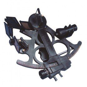
<h2>Sextant Davis Mark 15 from Topoplastic!</h2>
<p>This sextant is the reproduction of a real professional sextant. It is made of modern plastics, but it remains undeformable, shockproof and corrosion-proof. Light, robust and precise, this sextant is an indispensable navigation accessory. The Davis Mark 15 allows you to accurately determine all the points necessary for coastal and astronomical navigation.</p>
<h2>Detailed specifications of the Sextant Davis Mark 15 :</h2>
</div>

available
<div class="fiche-txt">
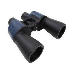
<h2>Waterproof Admiral RC binoculars for your sea trips!</h2>
<p>These marine binoculars are waterproof and have a magnification factor of 7 for use at sea. The optical diameter of 50 mm is the largest diameter recommended for the sea, it allows a comfortable holding in hand and a clear image. The eye relief makes them very pleasant to use and will delight spectacle wearers!</p>
<h2>Features of the Plastimo RC Admiral waterproof binoculars 7 x 50</h2>
</div>
available
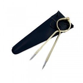
<h2>One Hand Brass Divider</h2>
<p style="text-align:justify;">One hand brass divider for aesthetics with fine stainless steel points for accuracy of measurement. The one hand divider is an indispensable marine instrument for measuring distances on a nautical chart whatever the scale, for determining its position in latitude and longitude or for positioning a point on the chart.</p>
<h2><span>Features of the One Hand Divider</span></h2>
available
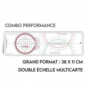
<h2>All the possibilities of the Cras rule and the Rappporteur Breton</h2>
<p style="text-align:justify;"><span>The Antares protractor ruler is both a tricolour Cras ruler AND a Breton protractor. It can be easily adapted to any skipper or sailor, whatever his or her initial training or practice habits. </span></p>
<h2>Features of the Antares rule</h2>
available
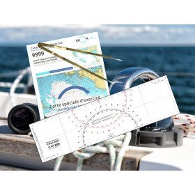
<h2><strong>The essential pack to prepare your offshore licence</strong></h2>
<p style="text-align:justify;">A set of quality tools to pass your offshore licence! Picksea is the owner of the Flash-Tide Instruments brand and our teams manufacture in France, in Lorient, all models of <a href="https://www.picksea.com/en/106806-cras-navigation-rules">rules cras</a> or Breton. Picksea is also a SHOM agent. We are therefore the best able to provide you with a pack composed of the best products at the best price.</p>
<h2>Composition of the offshore licence pack</h2>
available
In the same category
4 other products seleted for you-
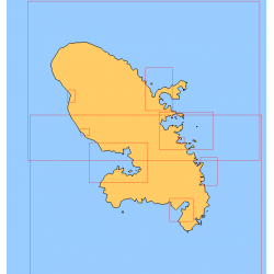
<div class="fiche-txt">
<h2>Choose in the list below a marine map of Martinique's surroundings</h2>
<p>This set of charts covers all the sailing areas of the island of Martinique in Shom marine charts of type L more adapted to the yachtsman because they are folded in A4 format, easier to store in a pleasure chart table. These maps detail precisely the navigation areas of the islands. Choose from the list below the area you wish to explore by referring to the chart number associated with the desired sailing area. Indicate the map number you have chosen in the comments of your order.</p>
<h2>List of chart references and areas covered:</h2>
</div>
available
-
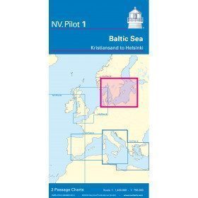
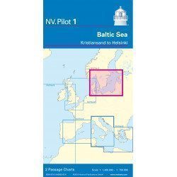
<h2>Baltic Sea Offshore Marine Chart</h2>
<p>The NV Pilot 1 offshore chart covers the Baltic Sea area from Kiel to Oslo on the front and the area from Skagerak (Flekkefjord) to Helsinki on the back.</p>
<h2>Details on the NV Pilot 1 - Baltic Sea map</h2>
available
-
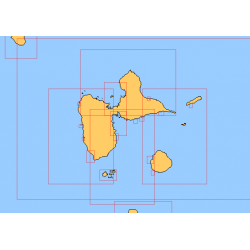
<div class="fiche-txt">
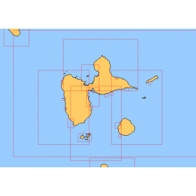
<h2>Choose in the list below a marine map of the surroundings of Guadeloupe</h2>
<p style="text-align:justify;">These SHOM charts cover all the navigation areas around Guadeloupe: from the Saintes to Marie-Galante and la Désirade as well as the Petit and Grand Cul de Sac Marin and the leeward coast, Saint François and Sainte Anne. If you need to reach Pointe à Pitre and the Gosier marina, you should choose the map of the Pointe a Pitre roadstead and the salt river. The Shom L type charts are more adapted to the yachtsman because they are folded in A4 format and thus easier to store in a chart table. They detail precisely the navigation areas of the coasts and islands surrounding Guadeloupe. To order, choose from the list below the area you wish to explore by referring to the map number associated with the desired navigation area. Indicate the map number you have chosen and the option "folded" or "flat".</p>
<h2>List of chart references and areas covered:</h2>
</div>
available
-
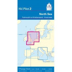
<h2>North Sea Offshore Marine Chart</h2>
<p><span>The NV Pilot 2 offshore chart covers the North Sea from Dover to Helgoland and Doggerbank in the North and the English Channel from Falmouth/Ushant to Dover on the front. On the reverse side, the area covers Great Yarmouth to Skagen, Inverness and the southern coast of Norway.</span></p>
<h2>Details on the NV Pilot 2 - North Sea map</h2>
available