available


€229.00 -10% €206.10 Tax included
error
Shipped within 10 days
-
Livraison à domicile : Gratuit
Une question ?
+33 2 97 11 80 95
Detailed features
A stable and ergonomic telescopic IOR pole
This telescopic IOR pole is very stable and ergonomic. It meets the requirements of the ISAF/ORC racing rules.
Characteristics of the Plastimo telescopic IOR pole
- Height:
- Unfolded: 3.52 m
- Folded : 1.95 m
- Above water : 2.30 m
- Dimensions:
- Float: height 360 mm
- Horn: 450 x 350 mm
- Material:
- Pole: fiberglass
- Float: Flexible, impact-resistant PVC
- 1/4 turn locking of the pole
- 4m yellow floating rope to connect to a lifebuoy
- Integrated lead ballast.
- Clamp and toggle to keep the flag rolled up.
In the same category
4 other products seleted for you-
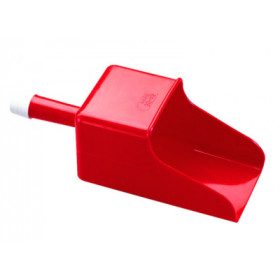
<h2>Funnel scoop with filter</h2>
<p>The Plastimo funnel scoop with filter is useful on boats for emptying or transferring any type of fluid by filtering it easily.</p>
available


-
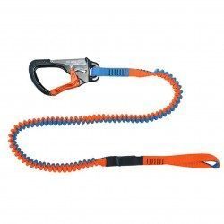
<h2>Lanyard - 2 meters - 1 carabiner, Racing version</h2>
<p>This lanyard is a high performance lanyard. This new model has lighter safety lines with a custom clip. It is up to 50% lighter and much more compact than conventional safety lines. Innovation also of the straps thanks to the Dry Coated which allows to reduce the absorption and to remain lighter for longer.</p>
<h2>The detailed characteristics of this Racing life span</h2>
available
-
<div class="fiche-txt">
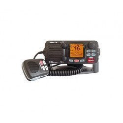
<h2><span><span><span>The FIXED VHF with integrated AIS receiver</span></span></span></h2>
<p><span><span><span>This fixed VHF RT550 from Navicom has a receiver </span></span></span><span><span><span><span>Integrated AIS</span></span></span></span><span><span><span>. It brings together the functions of li</span></span></span><span><span><span><dfn>ais</dfn></span></span></span><span><span><span>ons, transmission of distress messages </span></span></span><span><span><span><dfn>ASN</dfn></span></span></span><span><span><span> and reception of ship identification signals </span></span></span><span><span><span><dfn>AIS</dfn></span></span></span><span><span><span>. Nearby boats equipped with a transponder </span></span></span><span><span><span><dfn>AIS</dfn></span></span></span><span><span><span> are indicated visually on the display. An audible alarm sounds in case of dangerous proximity or risk of collision. Only one VHF antenna is required for reception </span></span></span><span><span><span><dfn>AIS</dfn></span></span></span><span><span><span> and VHF communications. </span></span></span></p>
<p><span><span><span>You will have access to many features with this VHF: 2 levels of power adjustable 1 and 25 W, a customizable display, an emergency call, a group call, an individual call, a dual watch, a position indicator, a transmission and reception level indicator, an intercom, a call log, a memory of the last call, external micro-poing, AIS receiver, alarm volume and key beep control, channel memory scan, priority channel scan, all channel scan, direct access key to channel 16, programmable BEEP keys and keypad lock.</span></span></span></p>
<h2><span><span><span>Features of the fixed VHF with integrated AIS receiver</span></span></span></h2>
</div>
available
-
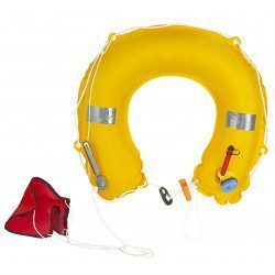
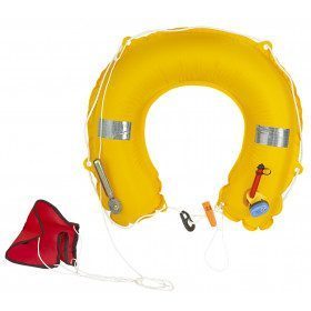
<div class="pvc-description entry">
<h2>2-part inflatable horseshoe buoy</h2>
<p style="text-align:justify;">This buoy is composed of two parts: a support positioned on the balcony of the boat and an ABS case containing the rescue device. The case is connected to the support by a rope. In the event of a man overboard, simply throw the case in the direction of the shipwrecked person.<br />The tension on the rope triggers the percussion. 150 N buoyancy: in accordance with division 240</p>
<h2>Characteristics of the inflatable horseshoe buoy</h2>
</div>
available