available


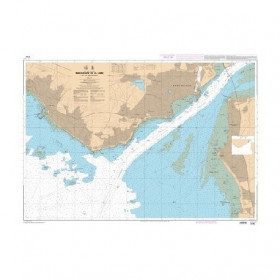
Marine chart 7405L : From La Rochelle to Pointe de La Coubre - Oléron Island

€39.00 Tax included
check_circle
Shipped within 24h
Une question ?
+33 2 97 11 80 95
Detailed features
Nautical chart for navigations around the Ile de Ré. SHOM 7404 L - From Pointe du Grouin du Cou to Pointe de Chassiron
SHOM chart number 7404 L
centered on the Ile de Ré
In the same category
4 other products seleted for you-
<h2 style="text-align:justify;">Imray Characteristics of the Imray C42 map La Rochelle to Santander</h2>
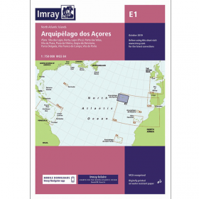
<p>Plans included:Lajes das Flores (1:20 000)Horta (1:12 500)Lajes do Pico (1:10 000)Velas (1:7500)Vila da Praia (1:10 000)Praia da Vitória (1:20 000)Angra do Heroísmo (1:12 500)Ponta Delgada (1:10 000)Vila Franco do Campo (1:15 000)Vila do Porto (1:10 000)Imray-Iolaire charts for the Atlantic Islands are widely acknowledged as the best available for the cruising sailor. They combine the latest official survey data with first-hand information gathered over 60 years of research by Don Street Jr and his wide network of contributors. Like all Imray charts, they are printed on water resistant Pretex paper for durability, and they include many anchorages, facilities and inlets not included on official charts.This edition includes the latest official data combined with additional information sourced from Imray''s network to make it ideal for small craft. It includes the latest official bathymetric surveys. Completed harbour works at Porto das Velas (São Jorge) is included and extra Marine Reserves are shown. For this edition magnetic variation curves have been added. There has been general updating throughout.</p>
available


-
<p style="text-align:justify;">SHOM marine chart 6797 for navigation in the mouth of the Loire up to the bridge of St Nazaire. SHOM marine chart type L folded to A4 format or flat, for pleasure boating. Up to date edition Scale: 1 : 15 000</p>
available

-
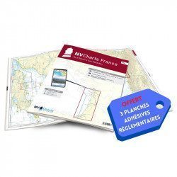
<h2>NV-CHARTS FR8 - 33 Aquitaine Marine Charts (from La Rochelle to San Sebastian) + the 3 regulatory adhesive sheets</h2>
<p><span style="font-size:10pt;">In this NV-Charts FR8 pack, you will find an Atlas of <span>33 Aquitaine charts from La Rochelle to San Sebastian including 3 offshore charts, 15 coastal charts and 15 detailed charts</span>. With a personal download code, you will have access to all the maps in digital format as well as the <strong>NV Graphical Navigator light navigation software</strong> both freely usable on PC, tablets or smartphone!</span></p>
<p><span style="font-size:10pt;">The areas represented are: <strong>Aquitaine - La Rochelle, Ré, Oléron, Rochefort, Royan, Gironde, Bordeaux, Arcachon, Bayonne, Biarritz, Saint Jean de Luz, San Sebastian (FRANCE)</strong></span></p>
<p><span style="font-size:10pt;"><span style="color:#ff0000;"><strong>Free with your FR8 pack:</strong> </span>3 adhesive sheets containing the mandatory regulatory documentation (RIPAM, buoys and flags) for navigation in coastal areas (art 242-2.04 of Division 240). <span style="color:#ff0000;"><strong>When you buy your pack, you have all the regulatory documentation for sailing within 6 miles of a shelter.</strong></span></span></p>
<h2>Description of the FR8 card pack</h2>
available
-
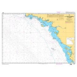
<p style="text-align:justify;">Shom 6990 marine chart for your navigations between Penmarc'h and the Gironde estuary. Scale: 1:355000</p>
available