available


Detailed features

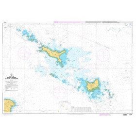
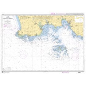
SHOM marine chart 7141 L. Quiberon Bay. Scale 1:20000
SHOM chart.
In the same category
4 other products seleted for you-
<p>SHOM marine chart 7143 L. Approaches to the islands of Houat and Hoëdic. Scale 1:20000</p>
available


-
<h2>NV-CHARTS FR6 - 36 charts of South East Brittany (from Lorient to Noirmoutier) + the 3 regulatory adhesive sheets</h2>
<p><span style="font-size:10pt;">In this NV-Charts FR6 pack, you will find an Atlas of <span>36 charts of South Brittany from Lorient to Noirmoutier including 3 offshore charts, 13 coastal charts and 20 detailed charts</span>. With a personal download code, you will have access to all the maps in digital format as well as the <strong>NV Graphical Navigator light navigation software</strong> both freely usable on PC, tablets or smartphone!</span></p>
<p><span style="font-size:10pt;">The areas represented are: <strong>South Brittany - Lorient, Etel, Belle-Île, Baie de Quiberon, La Trinité, Golfe du Morbihan, Vannes, Auray, Houat, Hoedic, La Vilaine, Piriac, La Turballe, Le Croisic, La Baule, Pornichet, Saint Nazaire, Nantes, Pornic, Noirmoutier (FRANCE)</strong></span></p>
<p><strong><span style="font-size:10pt;"><span style="color:#ff0000;">Free with your FR6 pack:</span> 3 adhesive sheets containing the mandatory regulatory documentation (RIPAM, buoys and flags) for navigation in coastal areas (art 242-2.04 of Division 240). <span style="color:#ff0000;">When you buy your pack, you have all the regulatory documentation for sailing within 6 miles of a shelter.</span></span></strong></p>
<h2>Description of the FR6 card pack</h2>
available
-
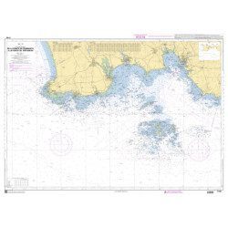
<p style="text-align:justify;">Shom 7067 marine chart available in folded A4 format or in flat A0 format (unfolded). Chart for navigations between the chaussée de Sein and Belle Ile. SHOM marine chart type Carte L, folded to A4 format, for yachting or flat format A0 (84 x 119 cm) for use in merchant marine. Updated print run: 2015 Scale: 1 : 160 900</p>
available
-
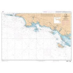
<h2>The SHOM marine chart 7146 L is the marine chart from the Pointe de Penmarc'h to the Pointe de Trévignon.</h2>
<p>Area covered: Le Guilvinec, Bénodet, Loctudy, Port la Forêt, Concarneau, Les Glénan. Scale 1:49,700.</p>
<h2>Characteristics of the SHOM 7146 L chart (folded version)</h2>
available