available


Detailed features

Marine chart SHOM 7136L. From Mahé Bridge to Piriac sur Mer. Scale 1:15000.
Card SHOM.
In the same category
4 other products seleted for you-
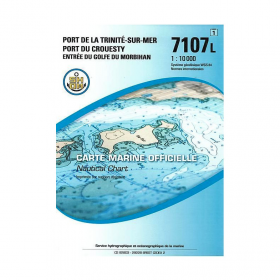
<p>SHOM marine chart 7107L : Harbour of la Trinité-Sur-Mer, harbour of Le Crouesty, entrée du Golfe du Morbihan. Scale 1:10000</p>
available
-
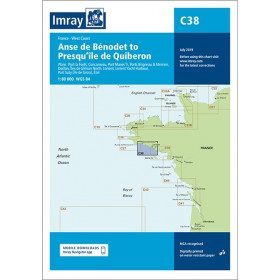
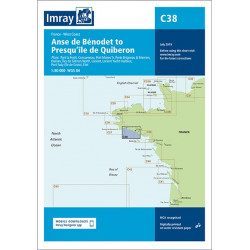
<h2 style="text-align:justify;">Imray C38 marine chart from Anse de Benodet to Presqu'île de Quiberon</h2>
<p style="text-align:justify;">On this edition, the latest survey information has been included where available. The port developments of Lorient and Concarneau and the Glénan Islands are included. The map specification has been improved to show coloured light flashes. A general update has been made.</p>
<p style="text-align:justify;">Maps included:</p>
<ul><li>Port la Forêt (1:15 000)</li>
<li>Concarneau (1:15 000)</li>
<li>Port Manec'h (1:35 000)</li>
<li>Brigneau & Merrien Ports (1:20 000)</li>
<li>Doëlan (1:15 000)</li>
<li>Glénan North Islands (1:30 000)</li>
<li>Lorient (1:35 000)</li>
<li>Lorient Yacht Harbour (1:10 000)</li>
<li>Port Tudy (Island of Groix) (1:10 000)</li>
<li>Étel (1:35 000)</li>
</ul><h2 style="text-align:justify;">Characteristics of the Imray C38 marine chart from Benodet to Quiberon</h2>
unavailable

-
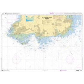
<h2>SHOM Marine Chart 7250L - From Pointe de la Torche to Loctudy</h2>
<ul><li>Scale 1:20000</li>
<li>Folded</li>
</ul>
available
-
available