available


Detailed features

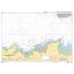
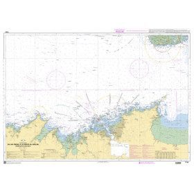
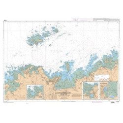
Marine chart for coastal navigation. SHOM 7124 L - Bay of Lannion - from Pointe de Primel to Ile Grande - Scale 1:20000
SHOM chart number 7124L. of the North Brittany region.
In the same category
4 other products seleted for you-
<h2>SHOM chart 7155L from Cap Fréhel to Pointe du Grouin and the approaches to Saint-Malo.</h2>
<p>Scale 1/48800.</p>
<p>Area covered: Cap Fréhel, Saint Cast, Lancieux, Approaches to Saint Malo, Dinard, Entrance to the Rance, Pointe du Grouin.</p>
available
-
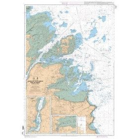
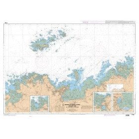
<p>Marine chart for coastal navigation. SHOM 7127 L - Bréhat Island - Paimpol Cove - Trieux Entrance. Scale 1:20000</p>
available
-
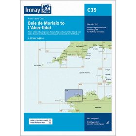
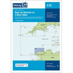
<h2 style="text-align:justify;">Imray C35 chart Morlaix to Aber-Ildut</h2>
<p style="text-align:justify;">In this edition, the chart specification has been improved to show coloured light flashes. Updated depth readings have been included where appropriate. Plans for the ports of Aber-Ildut and Argenton are now drawn at 1:25,000 scale. The plan showing the approaches to Roscoff has been extended eastwards to include better coverage of the approaches to Bloscon Marina. A general update has been carried out.</p>
<p style="text-align:justify;">Plans included:</p>
<ul><li>Aber-Ildut (1:25 000)</li>
<li>Argenton (1:25 000)</li>
<li>Portsall (1:20 000)</li>
<li>Approaches to Aber Wrac'h & Aber Benoît (1:30 000)</li>
<li>Port du Pontusval (1:15 000)</li>
<li>Moguériec (1:32 000)</li>
<li>Roscoff (1:20 000)</li>
<li>Port of Morlaix (1:15 000)</li>
</ul><h2 style="text-align:justify;">Characteristics of the Imray C35 chart from Morlaix to Aber-Ildut</h2>
unavailable

-
<p>Marine chart for coastal navigation. SHOM 7125 L - Approaches to Perros-Guirec - Scale 1:20000</p>
available