available


Marine chart 7094L : from the Four lighthouse to the virgin island - Aber Wrac'h

€39.00 Tax included
error
Shipped within 10 days
Une question ?
+33 2 97 11 80 95
Detailed features
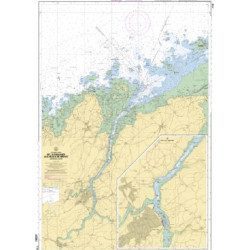
Marine chart for coastal navigation. SHOM 7094 L - From the Four lighthouse to the Virgin Island - Aber Wrac'h Port - Scale 1:25000
SHOM chart number 7094L. of the North Brittany region.
In the same category
4 other products seleted for you-
<h2>Marine charts 7126 L de l'Ile Balanec aux Heaux-de-Brehat : </h2>
<p>Scale 1:20 000 - Marine charts, SHOM : 7126L , from Ile Balanec to Heaux-de-Bréhat, and le cours du Jaudy.</p>
<h2>Features of marine charts 7126L : </h2>
available
-
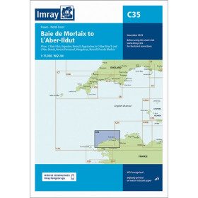
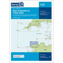
<h2 style="text-align:justify;">Imray C35 chart Morlaix to Aber-Ildut</h2>
<p style="text-align:justify;">In this edition, the chart specification has been improved to show coloured light flashes. Updated depth readings have been included where appropriate. Plans for the ports of Aber-Ildut and Argenton are now drawn at 1:25,000 scale. The plan showing the approaches to Roscoff has been extended eastwards to include better coverage of the approaches to Bloscon Marina. A general update has been carried out.</p>
<p style="text-align:justify;">Plans included:</p>
<ul><li>Aber-Ildut (1:25 000)</li>
<li>Argenton (1:25 000)</li>
<li>Portsall (1:20 000)</li>
<li>Approaches to Aber Wrac'h & Aber Benoît (1:30 000)</li>
<li>Port du Pontusval (1:15 000)</li>
<li>Moguériec (1:32 000)</li>
<li>Roscoff (1:20 000)</li>
<li>Port of Morlaix (1:15 000)</li>
</ul><h2 style="text-align:justify;">Characteristics of the Imray C35 chart from Morlaix to Aber-Ildut</h2>
unavailable

-
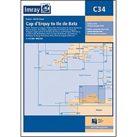
<h2 style="text-align:justify;">Imray C34 marine chart Cap d'Erquy to Ile de Batz </h2>
<p style="text-align:justify;">For this 2014 edition, the chart has been fully updated. Revised depths have been applied where necessary and the accuracy of the position relative to the WGS84 datum has been improved. The plan of the Port du Légué has been replaced with a plan to the correct scale.</p>
<p style="text-align:justify;">Plans included:</p>
<ul><li>Primel (1:15 000)</li>
<li>Le Léguer (1:42 500)</li>
<li>Trébeurden (1:25 000)</li>
<li>Ploumanac'h (1:10 000)</li>
<li>Anse de Perros (1:30 000)</li>
<li>Perros-Guirec (1:15 000)</li>
<li>Port-Blanc (1:25 000)</li>
<li>Approaches to the River of Tréguier (1:45 000)</li>
<li>Tréguier (1:15 000)</li>
<li>Approaches to the River Trieux and Paimpol (1:50 000)</li>
<li>Port de la Corderie (Ile de Bréhat) (1:15 000)</li>
<li>Port Clos (Ile de Bréhat) (1:10 000)</li>
<li>Lézardrieux (1:15 000)</li>
<li>Paimpol (1:15 000)</li>
<li>St-Quay-Portrieux (1:25 000)</li>
<li>Binic (1:12 500)</li>
<li>Port du Légué (1:20 000)</li>
<li>Dahouët (1:10 000)</li>
</ul><h2 style="text-align:justify;">Characteristics of the Imray C34 marine chart Cap d'Erquy to Ile de Batz </h2>
unavailable
-
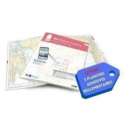
<h2>NV-CHARTS FR2 - 25 Western Channel Charts (from Cherbourg to St Malo) + the 3 regulatory adhesive sheets</h2>
<p><span style="font-size:10pt;">In this NV-Charts FR2 pack, you will find an atlas of 25 nautical charts from Cherbourg to St Malo, including 2 deep-sea charts, 14 coastal charts and 9 detailed charts. Thanks to a personal download code, you will have access to all the charts in digital format as well as to the <strong>NV Graphical Navigator light navigation software</strong> both freely usable on PC, tablets or smartphone!</span></p>
<p><span style="font-size:10pt;">The area represents the Channel (FRANCE), and more precisely the following areas: <strong>Channel Islands - Cherbourg, Granville, Chausey, Jersey, Guernsey, Cancale, Saint Malo.</strong></span></p>
<p><span style="font-size:10pt;"><span style="color:#ff0000;"><strong>Free with your FR2 pack:</strong></span> 3 adhesive sheets containing the mandatory regulatory documentation (RIPAM, buoys and flags) for navigation in coastal areas (art 242-2.04 of Division 240). <span style="color:#ff0000;"><strong>When you buy your pack, you have all the regulatory documentation for sailing within 6 miles of a shelter.</strong></span></span></p>
<h2>Description of the FR2 card pack</h2>
available