available


Detailed features

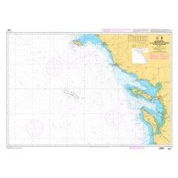
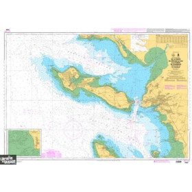
Shom marine chart for navigation from Oleron island to Arcachon basin. Scale: 1:167000.
SHOM chart number 7070L. of the Atlantic coast.
In the same category
4 other products seleted for you-
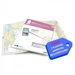
<h2>NV-CHARTS FR7 - 27 Vendée Nautical Charts (from Noirmoutier to La Rochelle) + the 3 statutory adhesive sheets</h2>
<p><span style="font-size:10pt;">In this NV-Charts FR7 pack, you will find an Atlas of <span>27 charts Vendée from Noirmoutier to La Rochelle including 3 offshore charts, 12 coastal charts and 12 detailed charts.</span> With a personal download code, you will have access to all the maps in digital format as well as the <strong>NV Graphical Navigator light navigation software</strong> both freely usable on PC, tablets or smartphone!</span></p>
<p><span style="font-size:10pt;">The areas represented are: <strong>Vendée - Noirmoutier, Ile d'Yeu, Saint Gilles Croix de Vie, Les Sables d'Olonne, Port Bourgenais, Jard sur Mer, Pointe de l'Aiguillon, Ile de Ré, La Rochelle (FRANCE).</strong></span></p>
<p><span style="font-size:10pt;"><span style="color:#ff0000;"><strong>Free with your FR7 pack:</strong></span> 3 adhesive sheets containing the mandatory regulatory documentation (RIPAM, buoys and flags) for navigation in coastal areas (art 242-2.04 of Division 240). <span style="color:#ff0000;"><strong>When you buy your pack, you have all the regulatory documentation for sailing within 6 miles of a shelter.</strong></span></span></p>
<h2>Description of the FR7 card pack</h2>
available
-
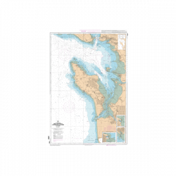
<p>Nautical chart for navigations around the Ile de Ré. SHOM 7404 L - From Pointe du Grouin du Cou to Pointe de Chassiron</p>
available
-
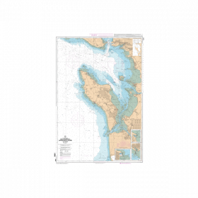
<p>Marine chart for navigations around the Ile de Ré. SHOM 7404 L - From the Pointe du Grouin du Cou to the Pointe de Chassiron</p>
available
-
<p>Shom 7069 marine chart for cruising around Yeu, Ré and Oléron. Scale: 1:164800.</p>
available