available


You might also like 1 other product seleted for you
-
<div class="fiche-txt">
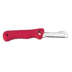
<h2>A floating folding knife to avoid losing it if it falls in the water!</h2>
<p>This folding knife is floating, so it won't end up on the bottom of the water if you accidentally drop it in the water!</p>
<h2>Characteristics of the Plastimo floating folding knife</h2>
</div>
available


In the same category
4 other products seleted for you-
<div class="fiche-txt">
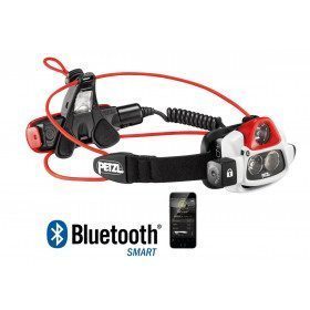
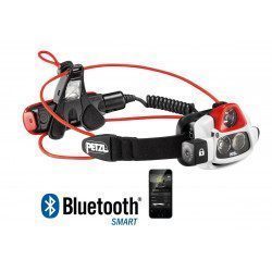
<h2>Ultra-powerful, rechargeable and programmable multibeam headlamp, thanks to the MyPetzl Light app.</h2>
<p>Equipped with REACTIVE LIGHTING® technology that automatically adapts the light intensity to the user's needs. With its power of 750 lumens, NAO + is the reference for night-time activities! Intelligent and programmable, it is totally at the service of performance. Thanks to the MyPetzl Light mobile application, the sportsman can consult, in real time on a smartphone or tablet, the remaining autonomy and adapt the performance of his headlamp. They can download predefined profiles or create their own custom profiles. During activity, with REACTIVE LIGHTING® technology, NAO + assesses the ambient light and adapts its lighting power to the needs of the athlete. With optimised energy and minimal handling, the athlete can concentrate on his activity!</p>
<h2>Detailed characteristics of the PETZL NAO+ rechargeable headlamp</h2>
</div>
unavailable
-
<div class="fiche-txt">
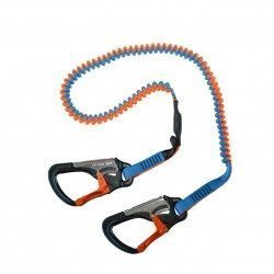
<h2>Elastic lifeline - 2 meters - 2 carabiners, Racing version</h2>
<p>This lanyard is a high performance lanyard. This new model has lighter safety lines with a custom clip. It is up to 50% lighter and much more compact than conventional safety lines. Innovation also of the straps thanks to the Dry Coated which allows to reduce the absorption and to remain lighter for longer.</p>
<h2>The detailed characteristics of this Racing life span</h2>
</div>
available
-
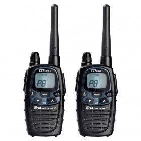
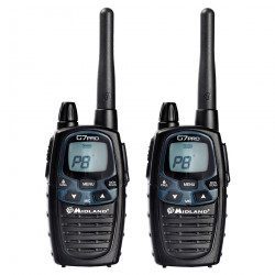
<h2>Walkie Talkie for easy communication</h2>
<p>High performance walkie talkie with a new, more modern design and the ability to boost transmit power. Better audio quality ensures that the G7 PRO communicates even more clearly. Very practical for communication on small bodies of water. Package content (blister pack of one pair) - 2 walkie talkies with clip - 2 NiMH 800mAh batteries - 1 double charger - 1 power supply</p>
<h2>Detailed features of the Midland G7 PRO Walkie Talkie</h2>
available
-
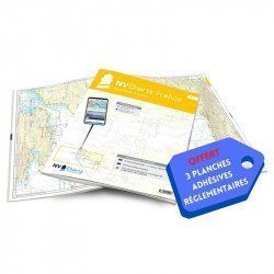
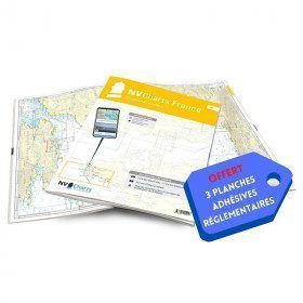
<h2>NV-CHARTS FR5 - 29 South West Brittany nautical charts (from Douarnenez to Lorient) + the 3 statutory adhesive sheets</h2>
<p><span style="font-size:10pt;">In this NV-Charts FR5 pack, you will find an Atlas of <span>29 charts of South-West Brittany, from Douarnenez to Lorient, including 2 deep-sea charts, 11 coastal charts and 16 detailed charts</span>. With a personal download code, you will have access to all the maps in digital format as well as the <strong>NV Graphical Navigator light navigation software</strong> both freely usable on PC, tablets or smartphone!</span></p>
<p><span style="font-size:10pt;">The areas represented are: <strong>South West Brittany Douarnenez, Sein, Audierne, Guilvinec, Loctudy, Bénodet, Port La Forêt, Concarneau, Les Glénan, Aven Belon, Doëlan, Groix, Lorient(FRANCE).</strong></span></p>
<p><span style="font-size:10pt;"><span style="color:#ff0000;"><strong>Free with your FR5 pack:</strong></span> 3 adhesive sheets containing the mandatory regulatory documentation (RIPAM, buoys and flags) for navigation in coastal areas (art 242-2.04 of Division 240). <span style="color:#ff0000;"><strong>When you buy your pack, you have all the regulatory documentation for sailing within 6 miles of a shelter.</strong></span></span></p>
<h2>Description of the FR5 card pack</h2>
available