available


Detailed features

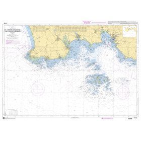
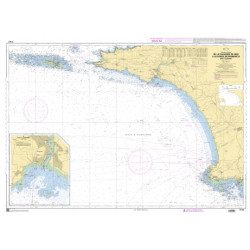
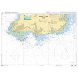
The SHOM marine chart 7148-CA is the marine chart from the Goulet de Brest to the Chaussée de Sein.
Area covered: Le Conquet, Molène, Goulet de Brest, Camaret, Ile de Sein, raz de Sein, Audierne. Scale 1:49,300.
Characteristics of the SHOM 7148-CA chart :
- Delivered rolled in a tube
- Open size A0 (84 x 119 cm)
You might also like 4 other products seleted for you
-
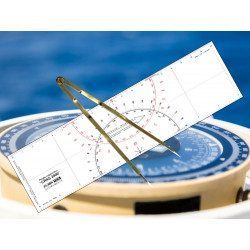
<h2 id="prod-h1" class="prod-name">Ruler and Compass Dry Point Kit</h2>
<p style="text-align:justify;"><span>Set of equipment to prepare for the offshore licence or to equip your boat, including a cras 2000 ruler (Flash-Tide) and a dry point compass (Flash-Tide)</span></p>
<h2 style="text-align:justify;"><span>Features of the Ruler and Compass Kit</span></h2>
available

-
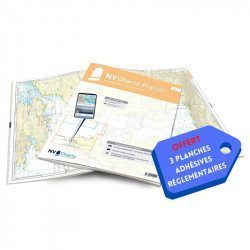
<h2>NV-CHARTS FR4 - 33 West Brittany Marine Charts (from the Seven Islands to Douarnenez) + the 3 regulatory adhesive sheets</h2>
<p><span style="font-size:10pt;">In this pack NV-Charts FR4, you will find an Atlas of 33 nautical charts from the Seven Islands to Douarnenez<span> including 2 offshore maps, 13 coastal maps and 18 detailed maps</span>. With a personal download code, you will have access to all the maps in digital format as well as the <strong>NV Graphical Navigator light navigation software</strong> both freely usable on PC, tablets or smartphone!</span></p>
<p><span style="font-size:10pt;">The areas represented are: <strong>Western Brittany - Roscoff, Morlaix, Ouessant, Molène, Brest, Camaret, Crozon, Morgat, Douarnenez, Sein (FRANCE).</strong></span></p>
<p><span style="font-size:10pt;"><span style="color:#ff0000;"><strong>Free with your FR4 pack:</strong></span> 3 adhesive sheets containing the mandatory regulatory documentation (RIPAM, buoys and flags) for navigation in coastal areas (art 242-2.04 of Division 240). <span style="color:#ff0000;"><strong>When you buy your pack, you have all the regulatory documentation for sailing within 6 miles of a shelter.</strong></span></span></p>
<h2>Description of the FR4 card pack</h2>
available
-
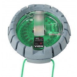
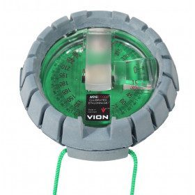
<h2>The VION Mini 2000 - "Mini Morin" bearing compass</h2>
<p style="text-align:justify;">This Vion Mini 2000 bearing compass is the famous "Mini Morin" famous in all cruising schools. Renowned for its solidity and reliability, it will find its place in your chart table and will assist you efficiently in your coastal courses.</p>
<h2>Features of the VION Mini 2000 bearing compass</h2>
available
-
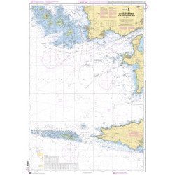
<h2>The SHOM marine chart 7147 L is the marine chart of the Chaussée de Sein to the Pointe de Penmarc'h and the Baie d'Audierne</h2>
<p>Area covered: Raz de Sein, Audierne, Pointe de Penmarc'h. Scale 1:29600.</p>
<h2>Characteristics of the SHOM 7147 L chart (folded version)</h2>
available

In the same category
4 other products seleted for you-
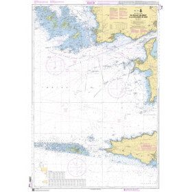
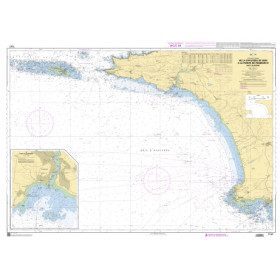
<h2>The SHOM marine chart 7148 L is the marine chart from the Goulet de Brest to the Chaussée de Sein.</h2>
<p>Area covered: Le Conquet, Molène, Goulet de Brest, Camaret, Ile de Sein, raz de Sein, Audierne. Scale 1:49,300.</p>
<h2>Characteristics of the SHOM 7148 L chart (folded version)</h2>
available
-
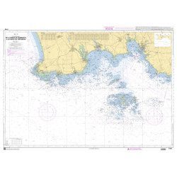
<h2>The SHOM marine chart 7146 L is the marine chart from the Pointe de Penmarc'h to the Pointe de Trévignon.</h2>
<p>Area covered: Le Guilvinec, Bénodet, Loctudy, Port la Forêt, Concarneau, Les Glénan. Scale 1:49,700.</p>
<h2>Characteristics of the SHOM 7146 L chart (folded version)</h2>
available
-
<h2>SHOM Marine Chart 7250 - From Pointe de la Torche to Loctudy</h2>
<ul><li>Scale 1:20000</li>
<li>Flat chart</li>
</ul>
available
-
available