available


In the same category
4 other products seleted for you-
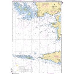
<h2>The SHOM marine chart 7148 L is the marine chart from the Goulet de Brest to the Chaussée de Sein.</h2>
<p>Area covered: Le Conquet, Molène, Goulet de Brest, Camaret, Ile de Sein, raz de Sein, Audierne. Scale 1:49,300.</p>
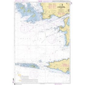
<h2>Characteristics of the SHOM 7148 L chart (folded version)</h2>
available
-
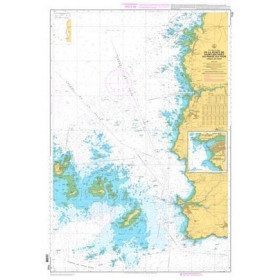
<p>Marine chart for coastal navigation. SHOM 7122 L - from Pointe Saint Mathieu to Four lighthouse - Scale 1:25000</p>
available


-
<div class="fiche-txt">
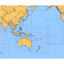
<h2>Choose from the list below an unfolded chart covering the sailing areas around Australia and South East Asia</h2>
<p>These maps detail the sailing areas of Australia, Oceania, and South East Asia. Frequently used as a decorative element or as a support to retrace a journey between continents. Choose from the list below the area you wish to explore by referring to the map number associated with the desired navigation area. Indicate the number of the map you have chosen in the comments of your order.</p>
<h2>List of chart references and areas covered:</h2>
</div>
available
-
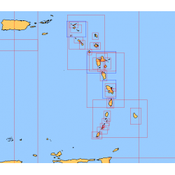
<div class="fiche-txt">
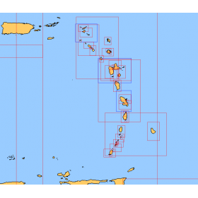
<h2>Choose from the list below a chart covering the sailing areas around the Caribbean Arc and the Caribbean Sea</h2>
<p>This set of charts covers all the sailing areas from Venezuela to Cuba, including all the islands of the Caribbean Arc. These Shom marine charts type L are more adapted to the yachtsman because they are folded in A4 format, easier to store in a yachting chart table. These charts detail precisely the sailing areas of the surrounding islands of the West Indies. Choose from the list below the area you wish to explore by referring to the chart number associated with the desired sailing area. Indicate the map number you have chosen and whether you want to sail flat or folded.</p>
<h2>List of chart references and areas covered:</h2>
</div>
available