available


Detailed features

Captain's Tools" set
Set of instruments to be used during navigation or for exams (deep-sea licence, professional navigation, ...). "The captain's tools" is the ideal gift for those who are passionate about navigation.
Characteristics of the box
"The Captain's Tools" is the perfect gift for the maritime enthusiast.
This set of instruments for use in navigation or for examinations (deep-sea licence, professional navigation, ...) includes :
- a Brocemer protractor
- a Cras 2000 rule
- a brass and stainless steel lyre compass
- a stainless steel brass compass
- three on-board stickers (markings, rules of the road and flags)
- a pencil and eraser.
Rigid printed cardboard box dimensions: 430 x 165 x 30 mm
10% discount compared to the purchase of separate products
In the same category
4 other products seleted for you-
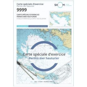
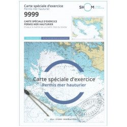
<h2 style="text-align:justify;">SHOM chart 9999 for the french offshore licence exam</h2>
<p style="text-align:justify;">The SHOM chart 9999 is the official chart for the offshore licence examination which allows you to navigate beyond 6 miles from a shelter. The 9999 chart is also used to do all the exercises to prepare for the exam.</p>
<h2 style="text-align:justify;">Training and preparation for the french offshore licence (theory test)</h2>
<p style="text-align:justify;">After passing the coastal licence (and perhaps also the inland waterway licence), you want to extend your navigation area to the "high seas"! To do this, you need to obtain a offshore licence to sail motorboats beyond 6 miles from a shelter (it is also very useful for sailing boats). You can read the article <a href="https://www.picksea.com/en/actualites-et-conseils/post/18-all-knowing-pass-license-holder">"Everything you need to know about the offshore licence"</a>.</p>
<p style="text-align:justify;">The chart 9999 is the official chart to take the offshore licence exam. Of course, this SHOM 9999 chart also allows you to work on all the exercises and mock exams in your school boat or as an independent candidate, to prepare for the tests for the offshore extension of the sea boat licence.</p>
<p style="text-align:justify;">The SHOM 9999 chart is a special marine chart but it contains all the information of a real navigation chart (scale of latitudes and longitudes, coasts, probes, dangers, beacons, lighthouses, currents, ...). You can plot routes and bearings and position points, or measure distances as on a real chart. See the article <a href="https://www.picksea.com/en/actualites-et-conseils/post/49-determine-route-direction-distance">"Determining a route in direction and distance" on our blog</a>.</p>
<p style="text-align:justify;">The SHOM (Services Hydrographique et Océanographique de la Marine) is the public organisation in charge of collecting data (soundings, currents, coastline, ...) and distributing this information, in particular in the form of nautical charts. Find here all our other SHOM charts.</p>
<h2 style="text-align:justify;">Characteristics of the SHOM 9999 Special Offshore Exam Chart</h2>
available

-
<div class="fiche-txt">
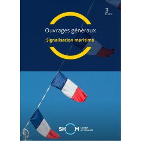
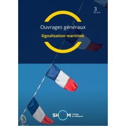
<h2>Marine Signage</h2>
<p>This book will allow you to know the maritime signage regulations and updated.</p>
<h2>All the Shom's regulatory works on our website</h2>
You can find on Picksea.com all the regulatory books of the Shom, like the good uses of the nautical documents 1F, or the book on the international regulation to prevent collisions at sea 2.</div>
available
-
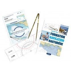
<h2><strong>Everything you need to prepare and pass your offshore licence!</strong></h2>
<p>Everything you need to prepare and pass your offshore licence: complete pack of materials, map and book</p>
<h2>Features of the Complete Offshore Pack</h2>
available
-
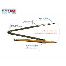
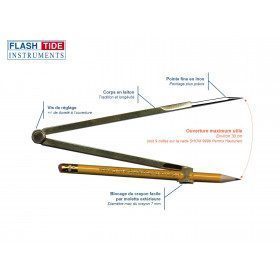
<h2>Marine Plotter Compass</h2>
<p><span>Brass marine compass with fine stainless steel tip for navigation. Pencil fastening by screw (adjustable height).</span></p>
<h2><span>Features of the Flash-Tide compass</span></h2>
available