available


Detailed features

Find the 4W buoy
Buoy that you will need to hang on the stern balcony of your boat to ensure the safety of the crew as required in Division 240.
- Complies with French regulations
In the same category
4 other products seleted for you-
available

-
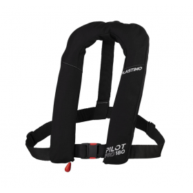
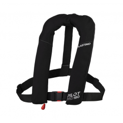
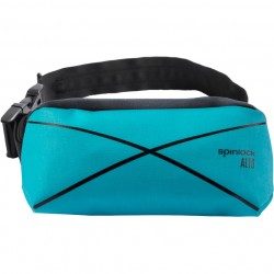
<h2>The reference in lifejackets: the manual Deckvest Alto 75N from Spinlock</h2>
<p>Designed for a range of water sports, the Alto product is a lightweight, compact, inflatable flotation device that is worn around the waist. The inflatable tube is manually released from the waist bag and supports the user under the arms. Alto offers users such as fishermen and small boaters a small, easy-to-use, go-anywhere airbag. In addition, once inflated, the product appears invisible, yet is certified as a buoyancy aid.</p>
<h2>Characteristics of the Deckvest Alto 75n vest</h2>
available
-
<div class="fiche-txt">
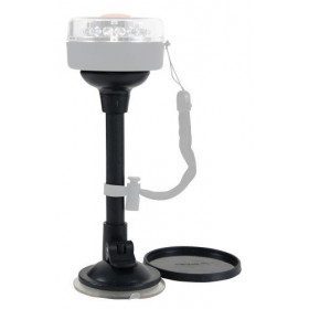
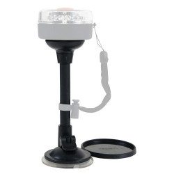
<h2>Suction cup holder for 360° navigation light and traffic light</h2>
<p>This rail mount has been designed to fit<a href="//www.picksea.com/fr/accessoires-marins/lampes-flashlights-bateau/lampes-led/feu-de-navigation-360-navisafe-24566.html"><strong> 360° navigation lights</strong></a> and the <a href="//www.picksea.com/fr/accessoires-marins/lampes-flashlights-bateau/lampes-led/feu-de-navigation-tricolore-navisafe-24568.html"><strong>traffic lights</strong></a>always by<strong> Navisafe</strong>. Its flexibility and quality are no longer in question, so this support will help you to install your navigation light perfectly.</p>
<h2>Characteristics of this support</h2>
</div>
available
-
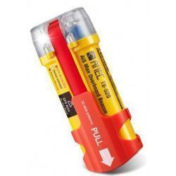
<h2>Personal AIS MOB beacon waterproof to 50 m</h2>
<p>The Amec TB 520 beacon, is a man overboard personal positioning beacon, using AIS technology. Vessels equipped with an AIS receiver in the vicinity of a person in the water carrying the TB520 beacon are alerted and receive the person's GPS position information. In emergency situations the beacon can be activated either automatically by the immersion sensor or manually. Its high performance GPS receiver allows the rapid acquisition of GPS coordinates. The TB520 beacon is small, but ultra reliable, and lightweight</p>
<h2>Features of the TB520 beacon:</h2>
unavailable